
Lion : quand GoogleEarth permet de retrouver d’où l’on vient / when Google Earth allows to refind where one comes from
Utiliser Google Earth pour retrouver son village natal /\ Using Google Earth to try to find his native village
Utiliser Google Earth pour retrouver son village natal /\ Using Google Earth to try to find his native village

Les géodispositifs rencontrés dans l’épisode VI de la saga Star Wars /\ Spatial machineries in Star Wars Episode VI
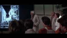
Les nombreux dispositifs spatiaux de La guerre des étoiles. Episode IV /\ The profuse spatial machineries in Starwars. Episode IV.

The Andromeda Strain is a 1971 American science-fiction film directed by Robert Wise and based on the novel The Andromeda Strain published in 1969 by Michael Crichton. It tells the story of a four-day major American scientific crisis, in a very structured way. Many and various spatial machineries support the narration : split screen, text…

From October 1, 2014 to January 18 2015, the exhibition « Hokusai » is held at the Grand Palais in Paris. This exhibition presents nearly 500 works by the Japanese artist Katsushika Hokusai (1760-1849), one of the most famous Japanese artists in the world today. Much of the works presented will never leave Japan after the opening…
Quand la Google car a parcouru Earl’s Court Road, à Londre, elle surpris le TARDIS, célèbre machine à voyager dans le temps et l’espace, aux allures de « Police Box », utilisée par le Doctor Who. /\ When the Google car mapped Short Earl’s Court Road, London, it caught the TARDIS, famous Doctor Who’s time machine and spacecraft, which looks like a Police Box.
The French artist Séverine Hubard (born in 1977) present at the Musée d’Art Moderne et Contemporain de Strasbourg (MAMCS) a temporary exhibition called Village. Work specially made for MAMCS, Village consists of an assembly of 18 « huts », mainly in wood and metal, hung together. This monumental work is eleven meters high. Installed in the…
Between 22 October 2013 and 24 August 2014, the Cité Universcience (Cité des Sciences et de l’Industrie) offers exhibition « Jeu vidéo l’EXPO » on a surface of 1000 m². This is the first major exhibition in France on video games, bringing their world a renewed look. Entre le 22 octobre 2013 et le 24 août 2014,…
« Immortel (Ad Vitam) » is a French sci-fi movie directed in 2004 by Enki Bilal, designer of world famous comics. It is one of three films directed by Enki Bilal, all directly inspired by his works, the atmosphere that emerges and their imaginary geographies. The stories all take place in a more or less distant future,…
From 16 October 2013 to 19 January 2014, the exhibition « Astérix at the BnF » holds at the Bibliothèque nationale de France (BnF) in Paris,. This exhibition proposes a wide number of original sketches, videos and many by-products of Asterix’s world. It gives an occasion to pinpoint the use of maps and spatial means in one…
Relief maps have a rather elegant rendering. Despite their decorative aspect, they are quite rare in fiction movies. This post attempts to begin an inventory of films with relief maps, beginning by 4 French movies. Les cartes en relief donnent un résultat assez élégant. Cependant il est plutôt rare d’en rencontrer dans les œuvres de…
Sébastien Caquard already pointed out here that James Bond used a geographic tracking device as early as in 1964 (Goldfinger). At that time, the idea of GPS technology was just emerging. At (e)space & fiction, we couldn’t keep ourselves from reacting to the debauchery of geospatial tools used in Skyfall, the latest James Bond movie, directed…
Duel, le premier film de Spielberg, qui raconte la poursuite d’une voiture par un camion fou est entièrement tourné au niveau du sol. Aucune vue aérienne, très peu de recul. La caméra est à hauteur des pare-chocs et de l’habitacle des véhicules, plus rarement sur un bas-côté à peine surélevé. Ce filmage tangentiel participe du…
Firefly is a TV series from 2002, wrote and directed by Joss Whedon (Buffy, Doll House, …). In Serenity, the film the same director released in 2005, the action takes place some time after the series. Firefly joyfully mixes and shakes up different film genres: science fiction, space odyssey, western, gangster and swashbuckler movies. It depicts in…
The inventory of geodigital tools used in the final season of theTV series « 24 » was released on Monde Géonumérique. It is added to the inventories of seasons 4 to 7 (self-promotion). L’inventaire des outils géonumériques utilisés dans l’ultime saison de la série télévisée 24 est paru sur Monde Géonumérique. Il rejoint l’inventaire des saisons 4…
Avatar – James Cameron’s film released in 2009 – takes place on the planet Pandora. The human coveted ore located beneath the natives’ village ground. At a briefing, soldiers try to localize their position with an interactive 3D holographic maps. Its handling is rather technical and tricky. The head of the crew fails to navigate…
Directed by Stanley Kubrick in 1980, The Shining is a horror film shot during the winter in a hotel isolated in the mountains of Oregon. Two sequences are located in a maze. Kubrick uses a map and a scale model of the maze in one of these sequences. Réalisé en 1980 par Stanley Kubrick, Shining…
Everybody knows or thinks he knows Mona Lisa, the most famous painting in the world. But it is also a mysterious work that has given rise to many rumors and speculations. We propose here an original interpretation that considers the painting as a sophisticated spatial and cartographic arrangement. We first build our reasoning upon an…
24 is certainly one of the most original and most influential TV series in recent years. It is also one of those with Alias that systematically use geospatial tools for telling stories. 24 (24 heures chrono en France) est certainement une des séries télévisées les plus originales et les plus marquantes de ces dernières années.…
